Tuesday forecast: Triple digit temps could arrive in parts of San Joaquin Valley
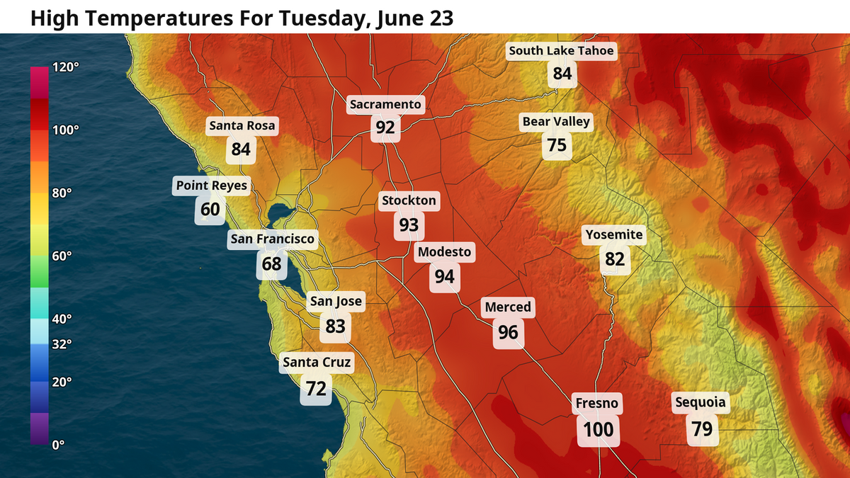
For San Joaquin Valley residents between Stockton and Merced, the benefits of the Delta breeze — with evening winds gusts at 20-plus mph — will prevent temperatures from rising into the triple digits.
The situation further south isn’t quite as pleasant. Fresno and communities south of it can expect 100-plus degree highs for the next three days.
As mentioned Monday, a ridge of high pressure over the Pacific Northwest will work to keep temps above average across the western U.S. through the mid-week. That means high temps in triple digits between Fresno and Bakersfield, alongside overnight lows of nearly 70 degrees.

For Sacramento, the building high pressure is a solid orientation for kicking up a moderate Delta breeze that will immediately bring relief as the sun begins to set every day through the rest of the work week. Gusts could occasionally reach 20 mph in the evening between Sacramento and Modesto as high temps are held only to the mid-90s.
.png "image (10).png")
Your forecast
Sacramento: It’s another calm start in the mid-50s for Sacramento. Temps will rise to 80 degrees by noon and briefly into the mid 90s by the afternoon before that Delta breeze kicks in. Rinse and repeat for Wednesday and Thursday. Keep an eye out for some clouds Thursday evening as the sun begins to set — that is cooler weather arriving, just in time for the weekend. Friday brings an extra breeze, some occasional passing clouds, and high temps reduced into the mid-80s.
Modesto: Three straight days of sunny skies, with lows in the low 60s and highs in the mid-90s, are on tap for Modesto between today and Thursday. The Delta breeze will also work to keep Modesto on the cool side during this period. Slight relief arrives this weekend with highs dipping into the mid- to upper 80s.
Fresno: The heat has returned! Much of the San Joaquin Valley near and south of Fresno will feel temps rise to around 100 degrees these later this afternoon and again Wednesday. Overnight lows during this time will be just shy of 70 degrees. Cooler temps arrive Friday with highs in the low to mid-90s and further this weekend as we dip into the upper 80s.
Looking ahead: A north wind, wildfire risk
As previewed yesterday, this summer heat is limited for now. On Thursday, a trough of lower pressure higher in the sky will arrive from the Gulf of Alaska and dominate the skies across the western U.S. through the weekend. Its arrival will likely kick up some occasional clouds and a strengthened Delta breeze between Thursday and Friday as temps begin falling.
By the weekend, high temps will drop back into the 80s. That Delta breeze will hold steady even through the cooler weekend thanks to a deeper marine layer and winds out of the west physically bringing the cooler temps inland. For folks on or traveling to the coast, be prepared for chilly conditions and some morning fog.
What will remain worth watching all week long is what this incoming trough means for our wildfire risk. As the trough arrives, it will drive northeast wind gusts of 30 mph or more across much of Northern California, with brief windows for mountain showers. Given rather dry conditions across the region, some advisories could be in the cards. We will continue to monitor this potential and keep you updated through the week.