Merced County holiday road and weather conditions: What you need to know
Merced County residents can expect more showers and possibly a thunderstorm Wednesday night with temperatures dipping into the upper 30s throughout the night, according to Meteorologist Jeffrey Barlow at the National Weather Service in Hanford.
Thanksgiving will see partly to mostly cloudy skies with a chance of showers and thunderstorms, with a high of around 50 degrees.
Cloudy conditions are expected throughout Thanksgiving evening with a slight chance of showers as the temperature dips to around the mid 30s, according to Barlow.
Friday will see a slight chance of showers in the morning with partly sunny skies and a high of around 50 degrees. A slight chance of rain will continue into Friday evening with low temperatures around the mid 30s or colder as a new storm system begins to move through the area Saturday.
Rain is expected Saturday evening, with areas of steady rain likely seeing a tenth to a quarter inch of rain throughout the night.
Showers and possibly stronger thunderstorms are expected Sunday which could produce about a quarter inch of rain. Temperatures are expected to be in the mid 50s Sunday.
According to Barlow, Monday morning will see about a 60% chance of rain as temperatures reach a high of around 60 degrees. Winds are also expected with gusts that could reach up to 25 mph.
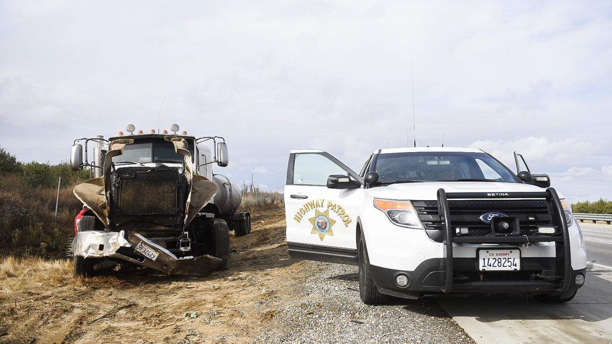
California Highway Patrol’s Merced County Office reported that with sunny skies and drying roads, there were three accidents Wednesday morning — no more than what’s typically seen. Traffic was light.
The most notable crash happened around 10:20 a.m. Wednesday in the southbound lanes of Highway 99 just south of Hammett Avenue. A big rig pulling an empty tanker veered off the roadway and crashed into a guardrail and electrical box, before traveling into a ditch.
No injuries were reported.
The Weather Service on Wednesday didn’t have a specific measurement of overnight rain that happened in Merced, due to issues with their measuring instruments.
Since the storm began Tuesday evening, however NWS measured .36 inches of rain in Fresno and .21 inches in Madera.
With the arrival of Wednesday’s storm, officials in Yosemite National Park announced the closure of Tioga Pass and Glacier Point roads until spring.
The projected snowfall in the Sierra Nevada and Kern County Mountains looks “on track” according to NWS Meteorologist Jim Anderson. Travelers between the Valley and Southern California should consider that snow has been reported in the Grapevine area on Interstate 5, Anderson said.
Travelers taking Interstate 5 may encounter delays, detours or closures on account of snow or flooding. Caltrans has reported I-5 closures north of Redding due to snow and south of Bakersfield due to flooding. Check the Caltrans website for updates.
“Slow down, use your turn signals and mirrors, and take your time to get where you’re going,” said CHP Officer Chris Mode.
Officers will be searching for unsafe driving practices such as failure to use a seat belt or intoxicated driving, Mode said.
Isolated power outages were reported around the Valley early Wednesday, according to Pacific Gas & Electric Co.
For those who will be traveling, there are good resources that can help them plan and be aware, according to Barlow. One of those resources people can use is the National Weather Service, Hanford website.
According to Barlow, the website offers people access to realtime satellite data as well as radar and weather forecasts.
Another resource people can use to help them plan while traveling is the Caltrans QuickMap app, or quickmap.dot.ca.gov, which can be used to check road conditions as well as traffic congestion and road closures, according to Barlow.
“Allow yourself extra time and go slow,” said Barlow. “We also encourage if you’re traveling to the mountains to take chains, blankets and extra food.”
This story was originally published November 27, 2019 at 11:53 AM.